The SeaTrac project is the latest example of one of PMEL’s strengths: collaborating with industry to transform a commercially available platform with NOAA-designed modifications to enhance ocean and atmospheric observation capabilities.
“The SeaTrac offers formidable adaptability, mission flexibility, reduced cost, ease of transport and zero carbon footprint,” said Scott Stalin, acting director of the NOAA Pacific Marine Environmental Laboratory’s Engineering Development Division. “It checks almost every box.”
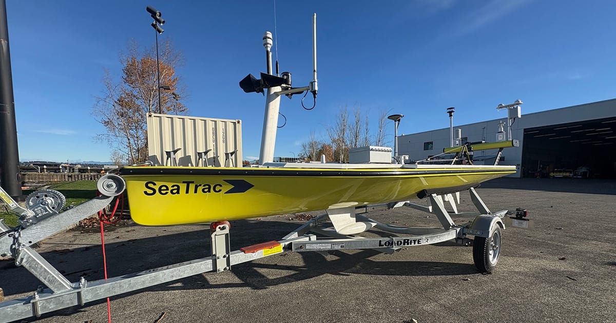
The SeaTrac is a mid-size ocean drone manufactured by a small Marblehead, Massachusetts company. At 15 feet long and 600 pounds, it can be easily towed, stowed, or trailered, enabling rapid deployment from ship or shore to respond to sudden events such as storms, buoy failures, or gaps in ocean observations.
Since it’s self-propelled, the SeaTrac can operate in conditions that challenge wind-powered USVs, such as calm winds, strong currents, or near the sea ice edge. Its ability to loiter on station like a buoy will allow it to lie in wait for an oncoming storm or atmospheric river. A flexible payload bay allows engineers to install or replace instruments to configure it for different missions.

The SeaTrac is an autonomous solar-powered uncrewed surface vehicle that can be modified to accommodate various atmospheric and oceanographic sensors and instruments. (Image credit: PMEL)
Testing and Validation
PMEL engineers recently conducted system tests near Puget Sound, programming an extensively modified SeaTrac to navigate from a shore deployment to a tsunami buoy. The deployment focused on validating sensor integration, data transmission reliability, and overall system robustness in a lower-risk environment before open-ocean testing.
Next, said Andy Chiodi, a research scientist with PMEL, they’ll assess the SeaTrac’s potential to serve as a low-cost, temporary replacement for a lost or damaged weather buoy. A SeaTrac fitted with advanced meteorological and oceanic sensor technologies will autonomously hold its position next to an operational buoy in the Pacific Ocean, allowing engineers to compare the two sets of observations for consistency and accuracy.
Beyond these initial tests, PMEL engineers believe the SeaTrac platform can support virtually every major PMEL research area. These applications include observing and understanding hurricanes, atmospheric rivers, marine heat waves, ocean acidification, the El Niño-Southern Oscillation, the California Current system, the ocean carbon sink, monitoring natural and human-caused sound, and oceanographic investigations that inform fisheries management.
Despite its robust capabilities, the platform remains relatively inexpensive, making it a cost-effective complement to ship-based surveys and mooring systems, Stalin said. Ownership of the craft means engineering and testing modifications are cost-effective, and NOAA owns the data instead of having to purchase it.
Over the years, PMEL engineers have designed or significantly advanced dozens of ocean observing systems supporting NOAA missions globally. They played a key role in advancing Saildrone technology, now used worldwide for hurricane and climate monitoring. They invented an instrument designed to enable USVs to measure carbon dioxide levels in both the ocean surface and the atmosphere, critical for understanding the ocean carbon sink. PMEL also invented the DART tsunami buoys, short for Deep-ocean Assessment and Reporting of Tsunamis, which are a cornerstone of the global tsunami warning system. PMEL scientists are already working on multiple ways to use the adaptable USV to support their research.

A PMEL-modified SeaTrac autonomous surface vessel maneuver near a PMEL-designed tsunami buoy in Puget Sound’s Shilsole Bay during testing on March 12, 2026. (Image credit: Matias Gradilla, CICOES)
Future SeaTrac Missions
PMEL’s SeaTrac is slated to assist a 2027 Integrated Ecosystem Research Program mission in the northern Bering Sea, where it would capture vertical profiles of currents, salinity, and temperature near the retreating ice edge during summer. An installed profiling winch on the stern will allow the SeaTrac to collect full water-column measurements to a depth of 250 meters in moderate sea states.
SeaTracs can be equipped with a special underwater microscope providing real-time awareness of plankton associated with harmful algal blooms (HABs). This summer, researchers with NOAA’s Great Lakes Environmental Research Laboratory will deploy a SeaTrac in Lake Huron’s Saginaw Bay to provide real-time data on harmful algal blooms (HABs). PMEL researchers are planning similar missions in the Bering Sea in 2027 and 2028, with a SeaTrac equipped with an autonomous environmental sample processor conducting on-board analysis for marine algae responsible for Paralytic Shellfish Poisoning.
“SeaTracs could provide real-time data to those who need it most when a harmful algal bloom is moving towards them,” said Zachary Gold, group lead for PMEL’s Ocean Molecular Ecology program, who envisions a fleet of future SeaTracs patrolling coastal waters to monitor HABs from Alaska to the West Coast, Great Lakes, and Florida. This fleet could provide critical early public health warnings to drinking water facilities, commercial fishing, aquaculture operations, subsistence harvesters, and recreation/tourism industries nationally.
SeaTracs could also be employed to validate remote sensing data collected by drones, aircraft, and satellites. They can also provide a cost-effective testbed for PMEL engineers developing new carbon sensors, deployed locally for evaluation alongside existing coastal Washington carbon dioxide monitoring buoys. They can be rapidly deployed to collect data or autonomous eDNA samples shortly after severe natural or anthropogenic events or during times of the year when vessel operations are not available.
“Having a fleet of observing systems that can be sent to measure an event as it develops and deliver both sustained and responsive observations will be key for understanding a rapidly changing ocean,” said PMEL oceanographer Adrienne Sutton.
Given their modest size, cost, and formidable flexibility, SeaTracs may surface as a player in an envisioned worldwide, ocean observing network called the SUN Fleet, which was recently endorsed by the Global Ocean Observing System, said PMEL oceanographer Meghan Cronin, one of the NOAA scientists leading the effort.
“USVs are capturing the attention and imagination of scientists around the world,” Cronin said.