
")
While the Atlantic hurricane season does not officially start until June 1, there are already “serious and growing concerns” about the impending season, AccuWeather Chief Meteorologist Jonathan Porter said.
There are two key factors that have AccuWeather forecasters sounding the early warning of a potentially super-charged season: The return of La Niña and historically warm water across the Atlantic Ocean.
La Niña to boost tropical activity
"The current El Niño pattern that is in place is forecast to transition into a La Niña pattern during the second half of the hurricane season," Porter explained. La Niña typically leads to more tropical storms and hurricanes in the Atlantic due to reduced wind shear, or disruptive winds high in the atmosphere.
The 2005 and 2020 hurricane seasons are tied for the most active in recorded history with each season generating 31 tropical systems. La Niña was building fast during the 2005 season and was firmly established amid the 2020 season.
It could be a back-loaded season in 2024, as La Niña might not officially develop until late summer or early autumn. "The second half of the hurricane season is likely to be very active, as conditions will be more favorable for tropical systems," AccuWeather Long-Range Expert Paul Pastelok said.
The timing of the onset of La Niña could also dictate whether this upcoming season will be similar to the 2020 season, or if the number of tropical systems will fall short of historic levels.
Still, residents along the Gulf Coast and Atlantic Seaboard should remain vigilant, as there is a risk for a system to develop before the official start of the hurricane season on June 1. This has become more common in recent years with a named tropical system developing before the official start to the season in seven of the past 10 years.
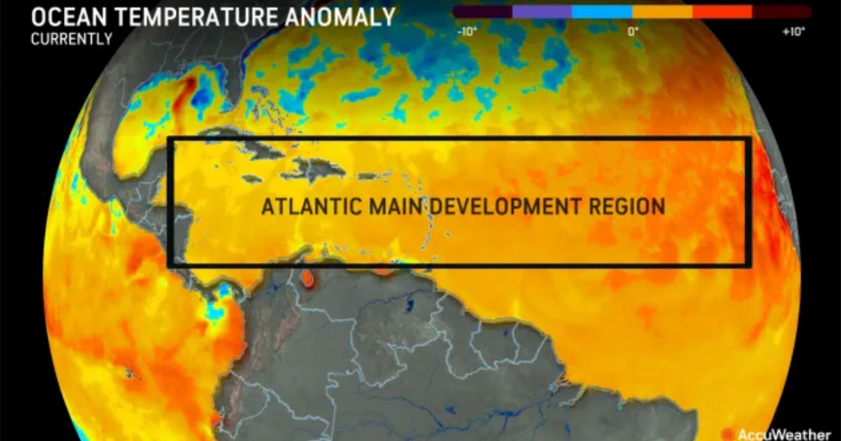
February ocean temperatures compared to 1910-2000 historical averages in the main hurricane development region of the Atlantic Ocean. Yellow, orange and red indicate areas where the water is much warmer than normal. (Image credit: AccuWeather)
Historically warm Atlantic Ocean ahead of hurricane season
Warm water is the fuel for hurricanes, and all signs are pointing toward potentially record-shattering warmth across the Atlantic hurricane basin during the summer and fall.
As of mid-February, the water temperatures across the Atlantic were at the same level where they typically are in mid-July -- and the temperatures may only rise as the days get longer and heat builds across the Northern Hemisphere heading into spring and summer.
Porter added that the water temperatures in the Main Development Region (MDR) at the end of January were a staggering 65% higher than the next closest year, a clear indication of how unusually warm the water is in this critical area of the Atlantic Ocean.
"Any storms that do form will have the potential to rapidly strengthen, even close to land, due to the exceptionally warm waters," Porter said.
The combination of building La Niña and historically warm water will lay the groundwork for a blockbuster season.
"We expect that the Gulf Coast, especially the Texas coast, will be at a higher risk for direct impacts from a tropical system this year," Pastelok added.
AccuWeather will release its full 2024 Atlantic hurricane season forecast on Wednesday, March 27.